Warning: Undefined array key "options" in /home/u290514632/domains/eagleeyedrones.in/public_html/wp-content/plugins/elementor-pro/modules/theme-builder/widgets/site-logo.php on line 192
The Ultimate Survey Drone: Revolutionize Data Collection With IQ8

IQ8 Survey Drone

Revolutionize Data Collection with IQ8: The Ultimate Survey Drone 8X

Introducing the IQ8 Survey Drone – your dynamic solution for unparalleled data collection. Experience 8 times the efficiency and accuracy as IQ8 redefines surveying capabilities. Elevate your projects with cutting-edge technology, unmatched precision, and swift data acquisition. Unleash the power of the IQ8 Survey Drone to transform the way you survey and innovate. 

Survey Drone

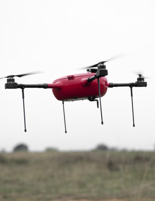
IQ8 UAV

  • IQ8 is Industrial grade Survey Drone for Industrial applications, It is small category.
  • Multirotor UAV providing flight time of upto 45mins and payload carrying.
  • capacity of upto 1750gms .

Applications

  • GIS Survey
  • Inspection
  • Surveillance
  • Multi-Spectral Imaging

Features

  • Quick Deploy.
  • Tool-less Assembly &
    Disassembly.
  • Easy portability.
  • Composite shell & Aerospace
    grade aluminum.
  • PPK & RTK*
  • 3 axis swappable gimbal*
  • Terrain follow*
  • Front obstacle avoidance*
  • Front person view*

IQ8 UAV

IQ8 is Industrial grade UAV for Industrial applications​

Unleash the power to enhance efficiency, precision, and safety across a myriad of sectors, from infrastructure and construction to agriculture and beyond. Elevate your industrial operations with the IQ8 and experience unmatched reliability and results.
Specifications

IQ8 Survey Drone

Delve into the extraordinary world of our state-of-the-art survey drone, meticulously crafted to redefine data collection. Boasting an array of exceptional specifications, this drone is equipped to deliver unparalleled performance. With its high-resolution camera, it captures intricate details with precision. The extended battery life ensures prolonged missions, while the advanced GPS technology guarantees accurate positioning. Designed for versatility, its lightweight frame facilitates effortless maneuverability even in challenging environments. Experience the future of surveying through the remarkable specifications of our innovative drone, setting new standards for efficiency and accuracy.

Power Plant Details

  • Motor : BLDC No of Motors: 4 Battery
  • capacity: 16ah / 22ah / 25ah (6s)
  • Propellers details: 16 or17 inch foldable prop

Payload Compatibility

  • Upto 1750gms 
  • Camera specifications: 24mp APSC CMOS sensor 3Axis Gimbal is compatible with industry standard cameras.

Remote Pilot Station

  • Ground control stations: Mission Planner /QGCS

Performance Details

  • Max Endurance: upto 45mins
  • Max Range: 5km Cruise Speed: 10m/s Area
  • Coverage: Upto 1.5 sq Km Operation
  • Altitude: upto 120m (default) can be unlocked upto 1000m
  • Operation Envelope : VLOS (BVLOS capable)

RPA Details

  • Small Quadcopter.
  • RPA weight without Battery & Payload: 2.9 Kg
  • Maximum
    takeoff Weight: 7 Kg
  • RPA (mm) (lbh)
    dimensions: 65X65X45 cm
  • RPA size after folding and removing
    landing gear: 47X35X21 cm
  • Payload capacity: up to 2.5kg
  • Foldable Arms Detachable Landing Gears

C2 Link

  • Range of communication : 5Km + (LOS)

Safety Features

  • FPV (Night & Day Vision).
  • Optical flow (Horizontal positioning redundancy).
  • Front obstacle avoidance and Altitude range sensor (Terrain follow)100m Range.
  • Dual Power redundancy for autopilot.
  • ROHS Soldering.
  • Dual GPS.
  • Power Train IP45.

Equipment Details

  • GNSS : 1 Gps, 1 Multiband GPS(1 Multi band L1, L2, L5)
  • Anti-collision strobe light Flight controller with flight data logging capability & Barometric Equipment

Power Plant Details

  • Motor : BLDC No of Motors: 4 Battery
  • capacity: 16ah / 22ah / 25ah (6s)
  • Propellers details: 16 or17 inch foldable prop

Payload Compatibility

  • Upto 1750gms 
  • Camera specifications: 24mp APSC CMOS sensor 3Axis Gimbal is compatible with industry standard cameras.

Remote Pilot Station

  • Ground control stations: Mission Planner /QGCS

C2 Link

  • Range of communication : 5Km + (LOS)

Performance Details

  • Max Endurance: upto 45mins
  • Max Range: 5km Cruise Speed: 10m/s Area
  • Coverage: Upto 1.5 sq Km Operation
  • Altitude: upto 120m (default) can be unlocked upto 1000m
  • Operation Envelope : VLOS (BVLOS capable)

Safety Features

  • FPV (Night & Day Vision).
  • Optical flow (Horizontal positioning redundancy).
  • Front obstacle avoidance and Altitude range sensor (Terrain follow)100m Range.
  • Dual Power redundancy for autopilot.
  • ROHS Soldering.
  • Dual GPS.
  • Power Train IP45.

RPA Details

  • Small Quadcopter.
  • RPA weight without Battery & Payload: 2.9 Kg
  • Maximum
    takeoff Weight: 7 Kg
  • RPA (mm) (lbh)
    dimensions: 65X65X45 cm
  • RPA size after folding and removing
    landing gear: 47X35X21 cm
  • Payload capacity: up to 2.5kg
  • Foldable Arms Detachable Landing Gears

Equipment Details

  • GNSS : 1 Gps, 1 Multiband GPS(1 Multi band L1, L2, L5)
  • Anti-collision strobe light Flight controller with flight data logging capability & Barometric Equipment

We Are Here For You

Know more about our product